SOUTH-CENTRAL, Ind. - The National Weather Service (NWS) in Indianapolis says that south-central Indiana will see an increasing chance for showers and thunderstorms this weekend. The biggest concern is from late Thursday night into Friday, when widespread, heavier rainfall may lead to flooding.
A total of 1 to 3 inches is possible for Bartholomew, Johnson, Jackson, Jennings, Shelby, Decatur, and Brown Counties, with locally higher amounts in some areas. Flash flooding may occur if heavier rainfall rates develop.
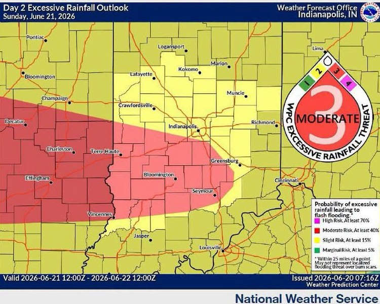
According to NWS, south-central Indiana is under a "Marginal Risk" (Level 1 of 4) for excessive rainfall on Thursday and a "Slight Risk" (Level 2 of 4) for excessive rainfall from late Thursday into Friday.
Hotter weather is predicted for Sunday, with the high around 90. Temperatures in the low to mid-90s are possible Monday through Wednesday of next week. Heat index values are expected to be in the 100-105 degree range, creating potentially dangerous conditions for individuals spending extended time outdoors.
 Jennings County repairs weather warning sirens after they failed last week
 North Vernon man busted for Fentanyl
 Local area is under 'Moderate' threat for heavy rain Sunday evening, Monday morning
 North Vernon Police bust Indy man for meth dealing, possession